![]()
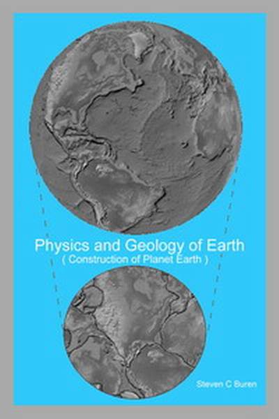
Physics and Geology of Earth
Published January 2006 by Steven C. Buren
Home Author Theology Mysteries WebLinks Family
Physics Politics Electronics Radio Baseball
Writers Email-Author Music Spitfire Beach
A Theory is the beginning to finding a Solution!
The best answers that any can obtain by the scientific methods are only probable, until the evidence is precisely verified.
A 52 pg pdf version- 5meg ----- A Windows-Word doc version 6meg
Physics-Geology-of-Earth.pdf ====== Physics-Geology-of-Earth.doc
This book was written almost 20 years ago, updates are in the following articles
Challenge your physics and math professors with these theories!
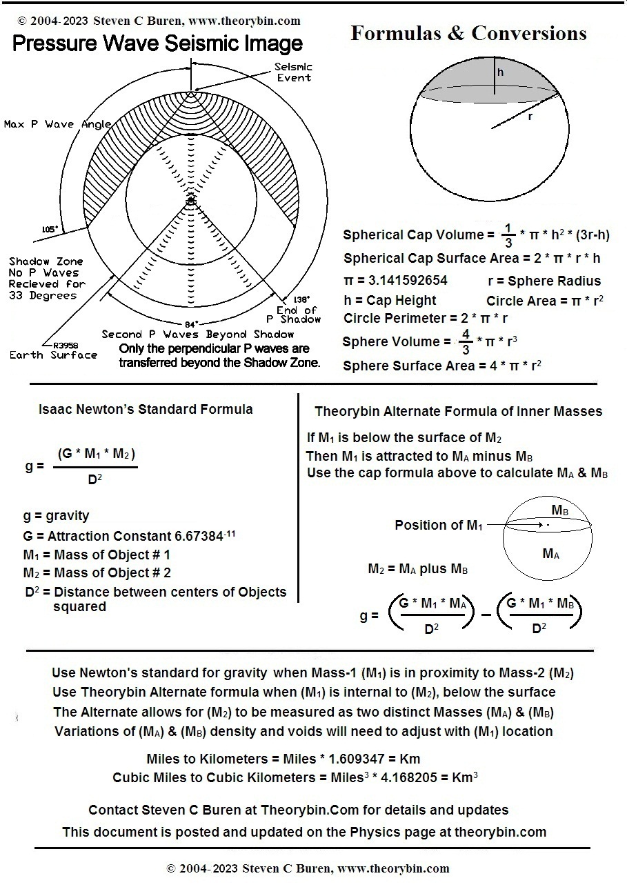
A simple lesson refuting some common teachingsGravity is a measure of Mass attracted to Mass - TrueDoes our Gravity increase to a pinpoint in the Center of Earth?No – contrary to common theories! In Center, there are equal measures of mass in all directions attracting outwardResulting in a balanced equilibrium of ZERO Gravity in the center of EarthThis is the same for all other planets, suns, and moons. The Black Hole, Big Bang, String Theory, and other related theories have twisted logics that rely on gravity increasing to a pinpoint; but those faulty calculations yield false conclusions!See the math formulas and more after text
Our moon when above; reduces gravity vectors by its counter mass that pulls tide waters. In the same effect; as an object enters the earth, mass below is reduced, and mass above is increased, thus, proportionally decreasing the perspective gravity. Notice (second page of this paper) in the Alternate Gravity Formula; that as M-1 approaches the Center of M-2, the gravity decreases to zero. That is the measure of a consistent density object. But if the object has gasses, then the gasses would migrate to the lower gravity area in the center, and thus naturally create a gaseous void. If the gaseous void were large enough, then we calculate the cavity gravity as if your proximity has two points of attraction. An inner surface point of the void will have an outward gravity perspective higher than the opposite side of the void in the distance. In effect, the inner surface of a hollow sphere, has an outward gravity attraction similar, but much less than the outer surface gravity toward the center of the mass. Thus it is very practical for any planet sphere to have a liquid inner sea within the void. - - - - - - - The persisting “Iron Core theory” of Earth was introduced in 1952 to explain the magnetic poles of Earth, which can move daily in an area of 200 miles. Our Earth magnetic poles are better reasoned as electrostatic forces induced from perpetual prevailing winds, which generate a magnetic field, over a hollow sphere. An insulated mass (air) moving over another mass (earth), creates a Vandegraff generated potential, opposite to the direction of movement. Our air at 14psi is 1-ton per square foot, or 28 megatons per square mile. Our air mass movements west to east create electrostatic currents east to west, which converge in our jet streams. Using (left hand rule) of magnetism, (fingers in direction of current) defines our (thumb) north pole by the direction of the induced current. The same field effect will generate on any planet with a sufficient prevailing movement of an atmosphere. - - Also - - Seismology articulations of the Earth’s Core, describe a Void more-so than a solid. “Any Mass whose Gravity Vectors point toward the Center of the Mass, has a Zero Gravity Equilibrium at its Center” Theorem by: Steven C. Buren 2004
All the Math calculations for these findings are on this page The image is derrived from the last page of Physics and Geology of Earth
We have the common and the modified formulas for calculating g - the gravity of an object. The Alternate Formula will utilize the Spherical Cap Volume formula to find equilibrium within a mass.
Notice in the Alternate Gravity Formula; that as M-1 approaches the Center of M-2, that gravity decreases to zero. That is the measure of a consistent density object. But if the object has gasses, then the gasses would migrate to the lower gravity area, and thus create a gaseous void. If the gaseous void were large enough, then you would calculate the cavity as if your proximity were in the area of equidistant satellites. Similar as approaching our moon, after you pass the gravity equilibrium, you would then be drawn to that mass more than the other mass. In effect, from the center of a hollow sphere, any position off center will have an outward gravity attraction to the nearest point of mass until a second equilibrium is reached within the body of the mass. Thus it is very practical for a sphere to have an inner sea.
This is why our moon can rotate the Earth and always face the planet from the same side. The moon is heavier on one side. This can only occur from a heavier offset mass, or a liquid/gas core where the liquid has moved to one side. The same effect is seen by placing some water in a soccer ball, then try to roll it on level pavement or place it in a pool. It will quickly stabilize and in a pool will maintain one side down and not roll.
Here are Geo-Math-2025.JPG and Geology-Flyer. PDF that can be copied, studied and distributed. There is a question on the Alternate Gravity Formula. Why are the Ma and Mb sections of M-2 calculated separately and then subtracted, instead of just replacing M-2 with (Ma-Mb) in a standard formula? The D2 of the mass center is a variable on both mass calculations. The distance measured is relative to the center of the portion of mass being calculated. Both positions will change by a change in the position of M-1. The calculations are effectively the same as measuring g between two adjacent spheres.
IF YOUR PDF READER DOES NOT DISPLAY AN IMAGE - Note: Acrobat PDF Reader may show a full page as a gray area. Correct this with Ctrl-K and check the box for "Display Large Images," (suggestion from a user)
|
Copyright January 30, 2006
Library of Congress Txu1-281-761
More information on the Physics Book Study is in the section on Author's notes. A narrative "Student Study" version of theories is intended for future publishing with additional emphasis on tornado initiators.
Physics and Geology of Earth
The cover represents the expansion of the Earth from 56% of the current size. When all continent outlines have their continent shelves included, the patterns combined will form a perfect sphere with very little distortion of the continent. The distortion is due to the change in radius of 2200 miles to 3958 miles. The radial change during a rapid expansion, is the action that created many of the mountain ranges and other features. Some mountains were created by collisions of continent components.
This is an 80 page in-depth scientific study that is packed with 29 astonishing theories and discoveries. Seismology data, when viewed in a Standard Waveguide Reflection Form, reveals that the Earth is hollow and has an Inner Sea that is 41 miles in depth.
The “Planet Structure” and “Planet Core” chapters will explain the singular expansion of the Earth as proved by the formation of all continents that can accurately assemble a smaller sphere. This will reveal the proof that the “Black Hole” and “Big Bang” theories are not possible.
“Any Mass whose Gravity Vectors point toward the Center of the Mass, has a Zero Gravity Equilibrium at its Center”
Theorem by: Steven C. Buren 2004
The “Global Earth Flood” chapter examines the catastrophic event that averaged 6 inches of rain/sleet per minute, to devastate and erase all land-based life on the planet. This planted the coal beds and fossil layers through hydrological sorting with no erosion between layers other than spillway canyons.
The chapter on “Planetary Magnetism”, proves that there is no spinning core in the Earth. Our magnetic field is generated by the prevailing winds that equate to 28 megatons of air mass per square mile, moving at an average rate of 20 mph. This air movement is equivalent to a VandeGraff Generator effect from the perpetual movements of insulated masses. The moon creating air-tides, the same as sea-tides, is almost entirely responsible for this air mass movement, and our magnetic field direction will never change unless the direction of rotation is changed.
Challenge your physics and math professors with these theories!
The following list is from the back cover of "
Physics and Geology of Earth".
OUTLINE of THEORIES and DISCOVERIES
(Comments in blue were edits after publishing, to add clarity and some changes)
Note: These theories build new foundations, and are easier to comprehend if studied in the order as written.
PLANET STRUCTURE
1 Gravity Inversion mathematically proves that the geometric center of Earth is zero gravity.
2 Seismic Data shows a liquid layer 41 miles deep at 1508 miles from the surface (Inner Sea).
3 Earth has a 2409-mile radius Gas Core (Hollow).
4 A Middle Equilibrium sphere of zero gravity exists at 1012 miles from surface of the planet.
5 The “Black Hole” and “Big Bang” theories are not possible due to materials that are over compressed will separate violently and not accumulate in over compressed masses.
PLANET CORE
1
2
All of the sediment material of the Mantle was once on top of the continents.3
Prior to the expansion, Gravity at continent level was near zero or inverted when Mantle material was above.4
All continents fit together (like a puzzle) onto a sphere of 2217 miles radius (about 56% of current size, with no land added or missing).5
Mountain Ranges were created when the continents changed 2217 miles radius to the current 3958 miles radius. (Some Ranges were created on continent impact with others during the expansion)6
Ocean ridges define the precise point to point lines of continent separation.7
Earth is cooling and shrinking, it has already shrunk at the poles. (Source of many Earthquakes through age & season cycles)
GLOBAL EARTH FLOOD
1
Flood Waters came from, and returned to the Inner Sea through at least one ocean trench (suspect Java Trench of Indian Ocean).2
An average of 6 inches rain, sleet, or floodwater per minute covered all mountains in 40 days. Forced from the Inner Sea & void pressure3
Diatom Earth (Limestone) surged from the interior with the floodwaters.4
Many extinctions and coal formations were made in this flood.5
Global Ice Age resulted from the decompression of interior gasses. (refrigerating the planet)6
Geomagnetism increase began with the decrease of atmosphere.7
Radius shrinkage or expansion of one foot would have a 6.28 foot lateral surface change. (Source of Earthquakes from Earth shrinking or expanding as it heats or cools in seasons)
PLANETARY MAGNETISM
1
Prevailing Winds induce 3 major electrical bands located at the Equator, and the North and South Jetstreams. (The induced current moves opposite to the flow of the winds)2
The combined effect of current bands, generate our Global Magnetic Field. (left hand rule of magnetism)3
The Magnetic Band Reversals found in the Ocean are a mis-interpretation of a linear split of magnetic material.4
Solar and Lunar gravitations create an Atmospheric Global Tide effect that is the major driving force for wind currents.5
Atmospheric layers can act as lenses to visually effect celestial observations. (high pressure - large moon) (low pressure - small moon)6
Sunspots are from celestial impacts, such as seen on the Shoemaker-Levy comet impacting Jupiter in 1994. (Sunspots occur most frequently during periods of seasonal meteor showers every 11 years)7
Jetstream-like wind troughs generate the disturbance current that drives hurricanes. Two or more storms on one side will force a balance8
A Hurricane Eye is a positive conduction path for a disrupted magnetic field. (electrically powered by the Jetstream & imbalance of offset storms)9
Hurricanes will commonly follow Ocean Trenches until forced to move to another trench. All drive energy ceases when they hit a Continent Shelf. (The trench is the least resistance of the electrical conduction path)10
Perpetual Trench Storms (Mendocino off California) generate lava flow heat by electrical conduction.
These 29 Theories and Proofs should shed enough light on the studies of Physics and Geology to warrant more extensive research. This listing is only an outline of the book that goes into much greater detail. The book also gives more minor discoveries and theories that lead to the major pieces listed. The Author welcomes any valid questions or discussions of the subjects listed in this website. Contact the Author by the feedback Email link that is on the menu of each page of this website.
Read the complete book of "Physics and Geology of Earth" for many more details and elaborated explanations with 50 drawings.
More information and concepts on the Physics Book Study, is available.
If there are science majors studying this material, let me know where you need more details, and which topics.
can be somewhat complicated, but explained here step by step in a three page PDF written for the theorybin web site. Click on the blue title and look this over to find answers about the stars that many astronomers can not and will not explain.
=== --- ===
Whirlwind by Design?
© Copyright 2005-2019 by Steven C. Buren from www.theorybin.com
Can the instability of a storm be Predictable?
Are the Cities and Counties un-intentionally designing Tornado alleys into their Landscape?
Recognize the initiators of tornado tracks that trigger an imbalance in super-cells. It is the imbalance of a dense thermal cell that unleashes the storms violent vortex updraft.
Identify the damage paths of past occurrences, as an effect of the initiator condition. This will locate the unstable areas that can be examined for the triggers of the super-cell imbalances.
It is currently understood that the super-cell cloud creates its own imbalance from collision with a cold front. Then a loop or curl forms in the South-West portion of the storm. These are predictions of the effect, after the triggers are already initiated.
What Is and What Causes the Imbalanced Condition?
The www.theorybin.com observations identify ground conditions that initiate the super-cell imbalance of falling on the north side and rising on the south side of a cloud or a thermal cell. The falling is a downdraft condition from forest or lake or river or elevation decline. The rising is an updraft condition from a desert plain or pavement or heated surface of buildings or elevating terrain.
When the updraft and downdraft conditions are directly aligned left and right to the path of a super-cell cloud, the cloud effectively begins to roll over. The downdraft area will produce a massive rain and downward airflow that draws an opposite updraft on the south side of the cloud. These occurrences will only initiate a rolling super-cell if the super-cell path is directly in line to the thermal or terrain imbalance of one side down and the other side up. Once the ground effect initiates the roll, the natural tendency of a rapid and localized updraft is triggered. If the super-cell is off center of an imbalanced terrain, and strikes only the downdraft area, it will rain. If the super-cell is only over the updraft terrain, it will pass on with no consequence; or maybe rain from the center or back of the cloud.
This is an untested theory, but what if a storm path is identified, then ambient ground temperatures are detail mapped ahead of the cloud cover path. A mapping of the storms predicted path will identify imbalances of terrain and temperature variations that can trigger the super-cell updraft-downdraft rollovers. In all cases of study, there were massive downpours on the opposite side of the storms, from the updraft conditions. The downpours are the cause of the updraft, and the thermal and terrain imbalance is the initiator of the rollover-downdraft condition.
Look for initiators of lowest temp areas (Lake, River, and Woodland) or down slope that would trigger the super-cell (anvil cloud) downdraft. If the downdraft areas are parallel or adjacent to an updraft or upward slope to the south, then the potential only needs a thermal cell or storm that spans both draft areas to generate the imbalance. Areas directly to the south of a lake at range of ten to twenty miles are the most vulnerable to tornadoes, especially if the surrounding features accentuate an updraft terrain.
The Oklahoma City area imbalance is theorized as triggered by the updraft below the main highway being a city (paved updraft) and desert terrain. The north section of the highway is forest and lake, forcing a downdraft in contrast to the southern portion. This is a Tornado path by design, that needs only a large cloud to span both the up and down draft areas.
The Joplin area is all forest and green field areas, but a down slope to the river to the north of the city is the downdraft area, while the city (paved updraft) is on a rising slope that forces and accentuates the updraft effect.
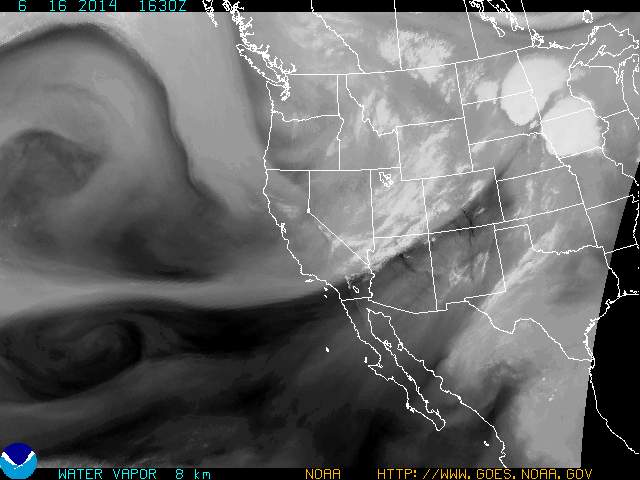
Another trigger method viewed is from the occurrence on June 16, 2014 of a double tornado in Pilger, Nebraska. These vortexes ran parallel to each other and parallel on the north side of a river that had a east-north-east direction. This condition was from two super-cells that traveled that direction, and they were split by a Jet-stream that perfectly divided the cells and vortexes on the path. That condition, as with Hurricane generated tornados is very rare and create their own energy that does not rely on the terrain.
How Can We Reduce the Imbalanced Conditions?
In each case of the initiators except the Jet-stream route, they may be dissipated of the trigger effect by relocating or adding lakes or ponds in the updraft areas. Another fix might be the reduction of the downdraft area, usually caused by a lake or forest. The triggers are notable and can be rebalanced with purposed examination and design changes. Such rebalancing by adding lakes before and within the common updraft paths should move or eliminate the reoccurrence of tornadoes in a common track with a frequent history of damages.
© Copyright 2005-2019 Updated March 1, 2017 by Steven C. Buren of www.theorybin.com
An early version of this Tornado theory was sent to the weather forecasters of Kansas on Nov-4-2015
Sent to NewsOK.com newspaper of Oklahoma City on Nov-7-2015.=== --- ===
Oklahoma Earth Quakes
While living in Kansas for 10 years+, the news frequently reported Quakes in Oklahoma, usually north of Oklahoma City and south of Perry & Pawnee in Indian Territories. These Quakes were notably in relation to seasons of spring and mid to late summer, and ALWAYS reported as being caused by excessive Oil Field Pumping. This correlation of Oil Fields and Earth Quakes gave the Government extra control for selling Annual Pump Permits for regulating and Greatly Limiting the flow.
There is Another Explanation for those Quakes that do not occur around other Fields in the US
EARTH QUAKE THEORY
For low depth of 200-300ft, as in Oklahoma areas.
Lakes are cycled High and Low Levels, anticipating large storms and seasonal rains. This Filling and Depleting Caverns accelerates leeching of Limestone Strata layers. A Depleted Cavern is Highly susceptible to Flood Surges that devastate natural structures. Those collapsing locations reported seem to run parallel and upstream to Dam Controlled Lake Branches. Investigations should confirm Collapsed Strata in Aqua Filled Voids, that feed Government Controlled Lakes.
Once again, Government Actions are creating the problem that is blamed on business
Reported to Oklahoma News and Civil Engineers, by Theorybin on June 7, 2015
© Copyright 2005-2019 Updated Oct 5, 2018 by Steven C. Buren of www.theorybin.com
Climate Change Propaganda
One of the primary "selective scientist" findings for proof of climate change or global warming is the rising sea levels. The UN political wing of government has convinced Holland of this, to where they are committed to strategies of doing their part to fix it. Holland has begun buying or confiscating their lowlands that are protected by dikes and windmill pumps, in a plan to flood these areas and "give" the land back to the seas.
In the 80's and 90's I used to live in Key Largo and Key West, Florida, and still maintain close ties to friends there and now live in Panama City Florida. The Keys are islands of south Florida which have the Atlantic on the East side and the Gulf of Mexico on the West side. The highest altitude in Key West is Solaris Hill, a graveyard that is eight feet above sea level. The islands are totally surrounded by Gulf and Ocean, and if one inch of variation were noticed in the charting of the waters, the people on these islands would be well aware of the changes. There is always a tide, high and low twice a day as well as storm surges, and the mean tides vary in different seasons. The fishing industry charts this precisely in the Solaris Hill and Keynoter Newspapers every day as predictable observable and reliable recordings and forecasts that have occurred since before the Civil War. My home in Panama City is about 18 feet above sea level, and I think my neighborhood would know of any change in tide markers over 100 years old.
Panama City has a tide record website as well as all other coastal cities, and the only thing rising in our sea levels are the hypo indoctrinated political scandals. We can search the world, and get a group of "selected scientists" to prove anything on our wish list, and that is exactly what the social policies have done. They exclude all scientific views that are contrary to their directives, no matter how profound the evidence, and accept only the hyper babble of their own predictions that support their agenda. Their private agenda is to support, control, and direct our government policies that extract our taxes for their pleasures. The nation used to label those who intentionally misdirected people, "TRAITORS" and communists. Look into real science proof before you start buying president BO's BS.
Commentary by; Steven C. Buren, June 2, 2014, and updated April 2015.
Other Websites of this and similar Science Study
I spoke with a friend Josiah (Hosiah) in Colorado and gave him my Physics book back in 2006. He posted a piece about this theory on his Blinding Light Website, calling it the "Jigsaw Continents," and that went through a lot of responses for a while. He didn't agree with the theory at first, but has learned more by watching an animation done by an artist Neil Adams. The artist has given the expanding earth some graphics and video's that are very interesting. There were several pieces that I can't agree with, and the continent movements by Mr. Adams are basic images that are not identical to my mapping, but my maps do not yet have video presentations. Josiah once told me: "Video is mightier than drawings and words," so that is still a future project. Are there any video masters to help out there?
Check out the Neal Adams Science section. With his 4 megs of imbedded animation, it will take a moment to load the page, but the video links on the bottom of his page are well worth the time, and he has another page that sells his video clips.
Home Author Theology Mysteries WebLinks Family
Physics Politics Electronics Radio Baseball
Writers Email-Author Music Spitfire Beach
Referring the Theorybin website to your friends
is a compliment to this work!
Copyright © 2004-2025 by Steven C. Buren. All rights reserved on all material on all pages in the Website theorybin.com and the books "Physics and Geology of Earth" & “Revealing Bible Mysteries”.
This text may be duplicated for classrooms and public speaking, provided the www.theorybin.com origin is stated
This page was last updated 12/23/24 by Steven C. Buren